


A quieter destination is not a secret to be extracted. The best lesser-known stops are places where access, resident life and the landscape still set the pace.
“Hidden” is about visitors, not value
New Zealand has few places that remain undiscovered in the literal sense. A stop can feel hidden to a visitor because it sits outside a familiar route, has limited promotion, or asks for more time than a day-trip schedule allows. For residents, the same place may be a home, a working landscape, a site of memory or a daily route. Quieter destinations still have residents, access rules and limited facilities, all of which shape how visitors can use them.
That difference matters when a place becomes popular through a photograph. A narrow road, small car park or fragile track can carry more visitors than the local infrastructure was built to handle. Quiet does not mean unregulated, unowned or available for unrestricted access. Respectful travel begins with the rules that apply on the day, then leaves room for the place to remain ordinary for the people who live there.
Instead of asking whether a destination is “undiscovered,” ask what makes the visit distinctive: a landscape transition, a regional story, an unusual walk, a locally run experience, or the chance to stay long enough to understand a town’s rhythm. That question produces better plans and more useful writing than a list of supposedly secret places.
Look for the shape of a good detour
- A short walk beside a small settlement
- It can add local texture without taking a full day. Check track status, tide or river conditions, parking and dog rules.
- A community museum or venue
- Local interpretation sits close to the place it describes. Opening hours may depend on volunteers or a short seasonal schedule.
- A slow road with a clear endpoint
- The landscape changes gradually instead of offering one viewpoint. Verify road surface, fuel distance, weather and driving restrictions.
- A regional event or food stop
- Locally run experiences connect a visit with people who live there. Check dates, capacity and any requests made by the hosts.
- A conservation site with managed access
- Visitors can learn about ecology and restoration. Permits, closures, biosecurity and visitor limits may determine when entry is possible.
Some of the most satisfying stops are not dramatic. A harbour walk before the shops open, a short forest track after rain, or a coastal settlement with a strong local history can create a lasting memory without a major attraction. The right choice depends on the route and the people travelling, not on an internet ranking.
Explore small places on their terms
Whangamōmona and the Forgotten World Highway
The Forgotten World Highway links inland Taranaki and Ruapehu through a landscape of steep hills, farms and small settlements. Whangamōmona is a memorable stop on that route, but the road is part of the experience: it is remote, winding and slower than its map distance suggests. A visit works best with daylight, fuel planning and time for a meal or a local conversation rather than a hurried photo at the boundary sign.
Roadside businesses and small museums can have limited hours. A fuel plan should account for services that close early, while accommodation should be reserved when an overnight stay is essential. The route’s quiet character depends on visitors driving carefully and leaving room for local traffic and farm vehicles.
Ōpārara Basin
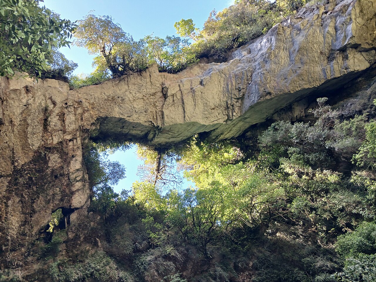
In the north-west of the South Island, the Ōpārara Basin offers limestone arches and forest within a distinctive landscape. Its appeal comes from geology and atmosphere, not from an unlimited number of nearby facilities. Track and road conditions matter; heavy rain can change access, and the basin sits away from a large urban base. Visitors who allow time for a short walk and a slower return are less likely to treat the place as a dash between coastal landmarks.
Wairarapa’s coast and inland edges
The Wairarapa is more varied than its wine-country image suggests. Small settlements, open coast, lagoons, farmland and rugged headlands can sit within the same regional journey. Cape Palliser and the coastal roads are not a casual add-on to a short Wellington day. Weather exposure, road conditions, wildlife and the distance between services shape what can fit comfortably.
Eastern Bay of Plenty around Kawerau
Kawerau gives a different doorway into forests, river country and geothermal landscapes. The area’s walks and local recreation are tied to real access arrangements; some sites require a permit or operate only on specific days. A local visitor centre or current official listing can clarify those terms. The details are part of the visit, not an obstacle to be bypassed.
- Ōpārara Basin near Karamea: the walk to Ōpārara Arch is about 1.1 km each way and takes around 30 minutes to reach the arch. From Karamea, the approach continues roughly 14 km along McCallums Mill Road, a narrow, steep gravel road with a recommended speed of 30 km/h; DOC says it is unsuitable for large vehicles and campervans. Rain can make the short track slippery, while the limestone formations are fragile. DOC’s Ōpārara Arch page lists current conditions.
- Te Paki Coastal Track, Te Tai Tokerau: the full route is 48 km and has four campsites, but it can be approached in separate sections. The short Cape Reinga/Te Rerenga Wairua–Te Werahi Beach route is 2 km return; longer sections cross exposed ridges and some beach approaches depend on tides. DOC notes that eating at Cape Reinga is not culturally appropriate, so a meal stop belongs at another point on the route. Track access, tide conditions and local notices determine whether a planned section is suitable. DOC’s Te Paki route notes describe the sections and access points.
What a low-impact visit looks like
- Arrive with a reason to stop. A local café, shop, museum or guide can make the visit useful to the community as well as interesting to the traveller.
- Use public facilities. Toilets, rubbish points and designated parking are not optional conveniences in places with limited services.
- Keep private land private. A track visible from the road is not automatically a public route. Gates, signs and local access notes matter.
- Leave wildlife undisturbed. Do not feed birds or marine mammals, approach nesting areas, or block a road for a photograph.
- Be ready to skip a stop. Flooding, closures, full car parks or a community event can make an alternative the more considerate choice.
These choices do not require a complicated code of conduct. They make travel more dependable for the people who live in a small settlement and for the next visitor who arrives after the road has been cleared or the track has recovered.
Plan detours around access
A practical detour has four pieces: a current access source, a realistic drive, a weather alternative and a place to refuel or eat before services thin out. For a walk, surface, grade, river crossings and return distance complete the practical picture; a single image rarely shows them. A short route can still be difficult if it is muddy, steep, exposed or reached by an unsealed road.
Remote destinations are often best placed at the beginning of a day, when there is more daylight and the driver is fresh. Overnighting nearby can transform a long detour into a comfortable regional stay. A last-minute detour on the way to an evening booking is the pattern most likely to make a beautiful place feel rushed.
Access information can age quickly. A track can close after a storm; a seasonal gate can change; a business can alter its hours; a small community can set a temporary restriction. Read official alerts on the day and treat a saved itinerary as a starting point. The Department of Conservation’s outdoor preparation guidance is useful wherever a “hidden” stop involves a track or public conservation land.
Pair one quieter place with a familiar base
New Zealand travel is easier when a lesser-known stop is paired with a town that has reliable accommodation, food and transport. A base gives the trip a margin for poor weather or a late start, while the smaller destination provides a different texture. A night in a regional centre can support a half-day in nearby countryside without forcing the entire route to depend on limited services.
This approach also reduces pressure on a fragile site. Visitors can choose a less crowded day, spend money in the host community and avoid leaving a vehicle in a small access area for hours. When the destination is already full, the nearby town often has alternatives that are just as rewarding and easier to reach.
Quieter does not always mean easier
A remote beach may have no lifeguard, a forest road may lack mobile coverage, and a small settlement may not have fuel after business hours. “Off the beaten path” is a description of distance from a major route, not a safety rating. The same trip-planning basics used on a New Zealand road journey apply with more force where services are sparse: share an itinerary, carry water, watch weather and know how to turn around.
For a larger regional trip, the South Island route planner and North Island guide set out the island-scale logistics. A lesser-known stop should fit into that wider travel shape instead of forcing every other day to move around a single destination.
Allow time for quieter places
A modest regional route might pair one small town, one walk and one overnight stay rather than stringing together five distant stops. The structure gives a local business time to be open, leaves daylight for the road and creates a reason to return to the same area if the weather changes. A slow day can be more valuable than a long list of viewpoints.
Distance calculations should include narrow roads, gravel, farm vehicles, road works and safe places to pull over. A short detour may require more time than a highway drive because the final approach is the destination. Check fuel before leaving the main corridor and identify the next reliable service while there is still daylight.
Small communities often rely on a limited set of public facilities. Parking across a driveway, leaving rubbish beside a full bin or arriving after a business closes affects residents as well as visitors. Spend where it is welcome, follow local signs and leave the site in a condition that does not add work for the people who care for it.